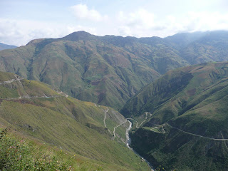
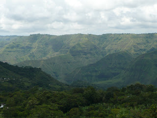
In southern Colombia, between Pasto and Popayan, the Andes forms this vast mountainous knot (the Colombian Massif) and from here, three mountain ranges begin to diverge from the main Andean chain, the Eastern, Western and Central cordilleras. The ranges unfold from the massif like a fan, radiating northwards, overlooking deep valleys and precipitous gorges. Above Popayan and Pasto the crest of the cordilleras are lined with a belt of volcanoes up to 4600m high and the eastern slopes are cloaked in dense cloudforest. The headwaters of Colombia´s two main rivers, the Magdalena and Cauca originate here too and they slice their way through a jumbled landscape on their long journey to the Caribbean. The scenery is spectacular and chaotic.
The ride through the canyon country between Popayan and Pasto was impressive, but some tough cycling. Lots of long climbs and steep descents. In one day´s cycling I climbed 2235 metres, which is a daily record for me. Mind you, it was on a sealed road and all below 3000m compared to the gravel roads and high altitude ascents over 5000m in Tibet. But it was both an exhilirating and strange few days. In the hot, humid Paita valley at 500m I was soaked in dripping sweat in the 40 degrees heat (I come from a long line of bald sweaters) and as I approached the pass at 2900, the heavy charcoal clouds burst overhead, drenching me. I was almost hypothermic when I wheeled into Pasto.


A Stratified Land
I crossed the provincial border between Cauca and Nariño in the Patia valley at 550m asl. In this low-lying and hot humid region, many blacks from the coast had settled at this elevation to grow sugar cane and bananas. As I climbed higher (1000-1500m) mestizos seemed to be the predominant racial group and maize and coffee replaced the crops below. On the higher and more remote mountain slopes (above 2000m), the indigenous campesino cultivates potatoes and grain. Pasto, the capital of Nariño, has a mixed population but it is the ladino (of European descent) who controls the business interests and is the face behind the till in the shops. Nariño, in a simplified way, is a microcosm of Colombia´s statified society. Its topography defines the demographics of the region and the racial composition, like the terrain, is layered according to altitude. It resembles a geological map where the earth is sliced horizontally into strata of racial, not rock, types. This is a stratified land.
San Agustin
This unique landscape was also the cradle for the ancient cultures of San Agustin and Tierradentro, both situated at 1700m on the eastern slopes of the Central cordillera. The two civilisations reached their peaks between 500-900AD. I visited the underground tombs of Tierradentro en route to Popayan, before crossing the massif. After a welcome rest in Popayan I left my bike at La Casa de Castrillon and ventured down to San Agustin by bus. A rough ride and not near as much fun as cycling. You can´t stop to admire the scenery or talk to the local campesinos. Unfortunately it was Easter holidays (Semana Santa) and hundreds of boisterous Colombians from Bogota descended on the town with their barking dogs and loud music.
The statues of San Agustin are very enigmatic. Many depict the jaguar in a human form, a motif seen in many Ameridian cultures. But some of them, with the bared fangs and silly smile, look less feline and more Wallace (from Wallace and Grommit fame) while others, with enlarged heads and squat torsos resemble the Tele Tubbies.


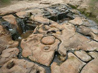
Fuente de Lavapatas site - petroglyphs carved into the bedrock of a stream.

Stone sacrophagus from one of the underground tombs.

On the way to the archaeological sites I came across this tarantula, the size of my hand. A beautiful specimen.

En route to San Agustin some wonderful floral displays in the cloudforest.


...and a waterfall and rainbow

I left the noisy crowds behind in the archaeological park and walked to the Chaquira petroglyphs, where human figures have been carved on a rocky outcrop above the deep ravine of the Magdalena river.

Then I climbed down the precipitous slopes down to the river (mostly sliding on my bum), discovering remnants of ancient terracing. The petroglyphs are on the crest of the hill on the right, overlooking the narrow defile of the Upper Magdalena valley.

At the river I crossed an old wooden bridge where an old campesino had just lit a candle in the tiny shrine.

The view from the bridge..waterfalls cascading into the Magdalena river.

Walking around this area you come across stone statues everywhere. Some farmers pointed out two lonely statues sitting in the middle of their coffee and banana fields.

Pasto to Ipiales
I decided to get away from the busy Pan American highway and head east on backroads to the Western Cordillera. Some nice riding in rural countryside around the slopes of Galeras Volcano, which is still active. Unfortunately it was overcast or raining....and didn`t get to see ol´ Smokey. But on the other side, in the Guaitara valley, the scenery was very impressive. Back in canyon country. I´ll have to return to Nariño in the dry season to explore the volcanic chain of the Western cordillera.

Back onto the Pan American Highway for my last day´s riding in Colombia. Que lastima!
What superb cycling country. It was another long climb from the spectacular Guaitara gorge at 1700m to Ipiales at 2900m. Here is a snap of the PanAm with the ubiquitous semi-trailer. Notice also the narrow shoulder, compared to the wide one in Ecuador in the next post.

In Ipiales there is a famous sanctuary which has recorded as many miracles as Lourdes. I wasn´t really in need of any (I´d had my miraculous journey already) so I took photos from afar. An austere Gothic affair, but in an amazing setting.


Outside Ipiales, a small indigenous community where all the shops are painted with interesting zoomorphic designs. This was the site of the guinea pig slaughterhouse.


3 comments:
hola peter!
soy álvaro, nos conocimos en el bus desde san agustín a popayán.
ahora estamos en el amazonas y después volveremos a la ruta por la panamericana en dirección a chachapoyas. estaré mirando por la carretera a ver si nos encontramos de nuevo.
me han gustado mucho las fotos y el blog me parece muy interesante, lo seguiré mirando de cuando en cuando para seguir tus aventuras.
buen viaje!!
ps. puedes seguir nuestra ruta en:
www.flickr.com/difusismo
Nice pics and post. The San Agustín Archaeological Park is located in Huila. Double SelfThis statue represents the guardians as well as the warrior which were engraved on the stone.El Partero who represents the male mid wife, El Obispo which means the bishop. La Fuente de Lavapatas is the most pretentious art work.
bonito fotos, mi Fav is Colombia, vivia en Cali una vez en 2004 para 3 meses
Post a Comment